What Is Being Proposed?
Heritage Group (through US Aggregates) has targeted ~1604 acres in the Little River Valley of Southwest Allen County, Indiana for acquisition, with ~913 acres in the current rezoning application for heavy industrial use. [WFFT Fox 55]
[Inside Indiana Business] The proposed development includes (read the filed application →):
-
A limestone quarry — open-pit mining within a ~710-acre industrial and quarry footprint (I3 Intensive Industrial + quarry zones), estimated to operate for 80–100 years, with a 7,500 sq ft scalehouse, 20,000 sq ft maintenance shop, and aggregate stockpiles [US Aggregates / Allen County D]
-
Two asphalt plants — each with 4 structures at ~50 feet (oil tanks) and 6 structures at ~85 feet (assumed silos); a major source of volatile organic compounds (VOCs) and particulate matter [US Aggregates / Allen County D]
-
A concrete batching plant — 4 ~100-foot silos, producing silica dust, cement particulate, and heavy truck traffic [US Aggregates / Allen County D]
-
A Norfolk Southern rail spur — a 3-track rail complex (~1.2 mi): a staging track, a dedicated loadout track served by 3 ~100-foot quick-load aggregate silos (conveyor- or elevator-fed from the quarry), and a run-around track for car repositioning [US Aggregates / Allen County D] — infrastructure scaled to serve a regional aggregate supply operation
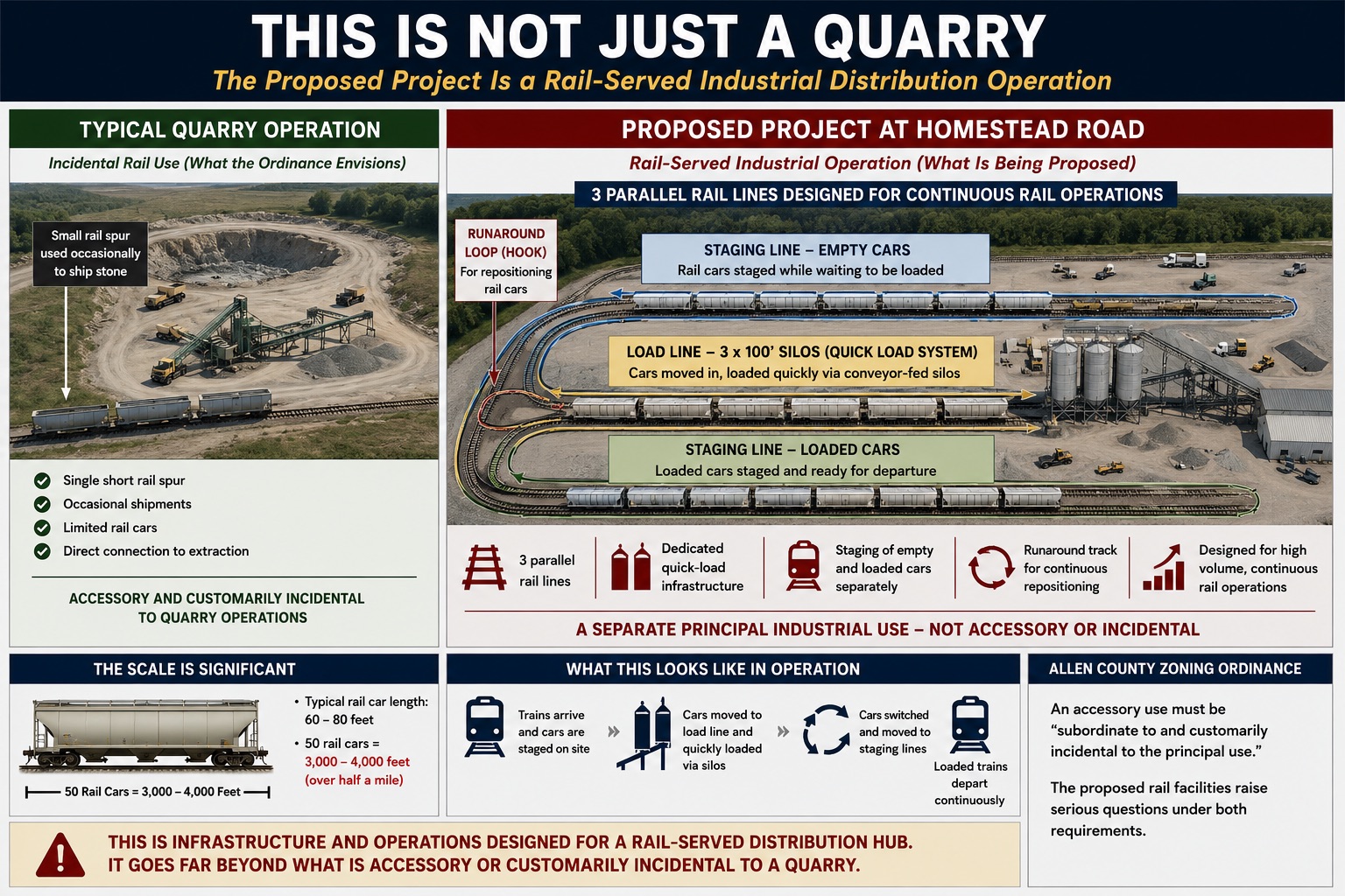
The filing identifies at least7 100-foot silos, 20 additional structures up to 85 feet, a 20,000 sq ft maintenance shop, and a scalehouse [US Aggregates / Allen County D] — and that is before accounting for crushers, conveyors, and other quarry equipment. Together, these facilities would represent one of the most significant industrial land-use changes in the region’s history. Of the ~1604 acres targeted for acquisition, ~710 acres are proposed for industrial and quarry operations (I3 + quarry zones); the current rezoning application covers ~913 acres.
Where Is This Happening?
The proposed site is in the Little River Valley in Southwest Allen County, Indiana — directly adjacent to residential neighborhoods, three schools, the IU Health Regional Campus, and protected wetland systems including Eagle Marsh. [WFFT Fox 55]
The surrounding area: [WFFT Fox 55]
- Borders at least eight completed residential neighborhoods
- Is in close proximity to three schools, including Lafayette Meadows Elementary
-
Is adjacent to the IU Health Regional Campus (under construction, borders the SC commercial zone of the site) [IU Health (via WFFT Fox 55)]
- Sits adjacent to Eagle Marsh and Fox Island — protected wetland systems that serve as critical wildlife habitat and regional flood protection
- Is part of the Little River watershed, which connects to downstream communities
- Is near commercial corridors along U.S. 24 and the Coventry shopping area
IU Health has publicly stated:“Operations like a rock quarry introduce noise, heavy truck traffic and industrial activity that can conflict with the healing environment we work hard to maintain.” [IU Health (via WFFT Fox 55)]
Is the Site Already in an Industrial Corridor?
No. The site is not in an industrial corridor today, and neither is the surrounding land. A central framing in the rezoning application is that the parcels lie within an existing industrial corridor — the county’s own zoning data tells a different story.
“The site is already in an industrial corridor.” — Rezoning application characterization
Within 1 mile of the proposed site boundary (5706.7 acres of zoned land), here is the actual zoning per Allen County's own GIS:
(the classification required for the asphalt and concrete plants proposed alongside the quarry)
The site itself is currently zoned A3 — Estates (Allen County).
See every zoning class inside the 1-mile ring
| Class | Description | Acres |
|---|---|---|
A3 |
Estates | 2269.3 |
A1 |
Agricultural | 1748.5 |
R1 |
Single Family Residential | 752.7 |
AR |
Low Intensity Residential | 356.7 |
SC |
Shopping Center | 150.8 |
R2 |
Two Family Residential | 103.1 |
C2 |
Limited Commercial | 80.9 |
R3 |
Multiple Family Residential | 68.4 |
C1 |
Professional Office and Personal Services | 66.6 |
C3 |
General Commercial | 55.4 |
NC |
Neighborhood Center | 23.3 |
I1 |
Limited Industrial | 8.8 |
C4 |
Intensive Commercial | 7.2 |
BTI |
Business Technology and Industrial Park | 7.0 |
I2 |
General Industrial | 5.1 |
RP |
— | 3.0 |
I3 |
Heavy Industrial | 0.0 |
Source: Allen County public GIS (Zoning_Polygons layer), clipped to the 1-mile ring around the proposed site boundary. Data pulled 2026-04-21.
The site itself is not in an industrial district today. Adjacent land is not in an industrial district today. The nearest existing industrial zoning is a handful of acres of light and limited-industrial (I1, I2) and a small Business Technology & Industrial Park (BTI) parcel. There is no Heavy Industrial (I3) zoning anywhere inside the 1-mile ring, and the rezoning application is asking to create that classification here from scratch.
Who Is Behind It?
The applicant is US Aggregates, a subsidiary of The Heritage Group based in Indianapolis. [WFFT Fox 55] Public zoning filings and county documents are the primary sources. The application can be tracked through the Allen County Planning Services portal and the Agenda Center. [Allen County Department of Pla] Official filings and technical reports are also available on our Application Documents page.
What is Heritage Group’s worker safety record at its Indiana limestone quarries?
US Aggregates, a subsidiary of The Heritage Group, has recorded two worker fatalities at active Indiana limestone quarries — the same operation type and commodity proposed for Homestead Road — along with an imminent danger shutdown and dozens of high-negligence violations across its Indiana quarry network, according to federal Mine Safety and Health Administration (MSHA) public enforcement records. [U.S. Mine Safety and Health Ad]
October 2007 — Delphi Plant, Carroll County, Indiana
Samuel Kemp, 36, assistant superintendent at US Aggregates’ Delphi Limestone Company, was fatally injured on October 24, 2007, while attempting to remove a loader bucket tooth lodged in a crusher. Kemp and co-workers placed jacks beneath the obstruction to free it; the jacks failed and dislodging material struck Kemp in the head. He was hospitalized and died October 29, 2007. MSHA’s investigation found that management procedures were inadequate and that the manufacturer’s published crusher-clearing protocols were not followed. [U.S. Mine Safety and Health Ad] A high-negligence citation was assessed at a $60,000 penalty. [U.S. Mine Safety and Health Ad]
May 2024 — Flat Rock Plant, Shelby County, Indiana
Sean Marek, 44, a contractor and U.S. Navy veteran, was electrocuted on May 8, 2024, at US Aggregates’ Flat Rock Plant in Shelby County when a crane contacted overhead high-voltage powerlines while lifting a conveyor belt. Marek was touching or in close proximity to the crane rigging at the time. MSHA’s investigation found that US Aggregates failed to: conduct an adequate workplace examination of the area where the work was performed; provide site-specific hazard awareness training; and conspicuously mark or barricade the overhead powerline hazard. [U.S. Mine Safety and Health Ad]
MSHA issued Unwarrantable Failure orders under 104(d)(1) of the Mine Act — the most serious enforcement classification below an imminent danger shutdown — citing high negligence on the part of US Aggregates. More than $110,000 in penalties are proposed; enforcement proceedings remain active. [U.S. Mine Safety and Health Ad] Marek’s family has filed a civil lawsuit against Heritage Aggregates LLC (d/b/a US Aggregates) in Marion Superior Court. [The Indiana Lawyer]
Both fatalities occurred at surface crushed limestone operations in Indiana — the same mine type, commodity, and state as the Homestead Road proposal. Federal enforcement records for The Heritage Group and US Aggregates reflect a total of 1,183 violations across their Indiana operations, including the two fatalities above, multiple high-negligence Significant and Substantial citations, and unwarrantable failure findings spanning facilities in Carroll, Shelby, Tippecanoe, and other Indiana counties. [U.S. Mine Safety and Health Ad]
How does Heritage Group’s safety record compare to the industry?
Using MSHA’s annual employment data — the same figures mine operators report to the federal government — Heritage Group’s rates are 4.7 times the national average for fatalities and 2.0 times the national average for lost-time injuries per 200,000 employee-hours worked. [U.S. Mine Safety and Health Ad]
[U.S. Mine Safety and Health Ad]
| Operator | Fatality rate | Lost-time injury rate |
|---|---|---|
| The Heritage Group / US Aggregates | 0.069 | 2.33 |
| Cemex | 0.033 | 2.78 |
| CRH | 0.020 | 1.00 |
| National M/NM average | 0.015 | 1.15 |
| Summit Materials | 0.052 | 0.82 |
| Heidelberg Materials | 0.009 | 0.71 |
| Holcim | 0.016 | 0.51 |
| Vulcan Materials | 0.007 | 0.50 |
| Martin Marietta Materials | 0.012 | 0.43 |
Rates per 200,000 employee-hours. Source: MSHA accident records and annual employment/production data, 2000–present.
Heritage Group’s fatality rate exceeds every major aggregate industry peer. Its lost-time injury rate is above the national average and higher than all major peers except Cemex. The complete enforcement record is publicly searchable through MSHA’s open government data portal. [U.S. Mine Safety and Health Ad]
What do Heritage Group’s dust and silica records show?
Limestone quarrying generates respirable crystalline silica (RCS) — fine quartz dust that causes silicosis, an incurable and potentially fatal lung disease, and is classified as a known carcinogen. [U.S. Occupational Safety and H] MSHA conducts personal air sampling at active mines to verify compliance with exposure limits.
Federal sampling records show Heritage Group and US Aggregates had 10 documented silica overexposures at Indiana quarry operations, all resulting in citations. The worst measured 5.06 times the legal exposure limit for respirable quartz — affecting a truck driver at a Lake County operation. Workers at crusher operations and dry-screen plant positions were exposed at 2.2–2.6 times the legal limit at a Pulaski County quarry across multiple inspections. [U.S. Mine Safety and Health Ad]
The jobs with documented overexposures — crusher operators, screen plant workers, truck drivers, and front-end loader operators — are the same roles that would operate at the proposed Homestead Road facility. MSHA formal violations records include 2 Significant and Substantial citations for silica dust standards and 10 separate violations of the diesel particulate matter standard (CFR 56.4101), which governs engine exhaust from mining equipment. [U.S. Environmental Protection ]
[U.S. Mine Safety and Health Ad]
What Is the Timeline?
On May 26, 2026, the Allen County Board of Zoning Appeals voted 4–0 to deny US Aggregates / Heritage Group’s special use variance request (one member absent) following a nearly three-hour public hearing. The developer subsequently withdrew their rezoning petition before the Plan Commission, which accepted the withdrawal in minutes. The project has no current approval pathway. The developer may appeal the BZA decision within 30 days or reapply with a substantially changed proposal after approximately one year. Key dates and decision points are tracked on our Timeline page.
Why Does This Matter?
Once a quarry is approved and mining begins, the land-use change is effectively permanent for multiple generations. The impacts — to air quality, groundwater, wetlands, property values, and quality of life — would be felt for 80–100 years.
This is the moment to act.
Learn More
- Science & Data— Research on environmental and health impacts
- Maps — See how the proposed site overlaps with your neighborhood
- Take Action — How to make your voice heard